

000
ABPZ20 KNHC 061133
TWOEP
Tropical Weather Outlook
NWS National Hurricane Center Miami FL
500 AM PDT Tue Oct 6 2026
For the eastern and central North Pacific east of 180 longitude:
Active Systems:
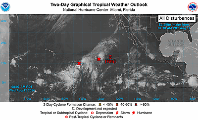
The National Hurricane Center is issuing advisories on Hurricane
Rachel, located several hundred miles west-southwest of the
southern tip of the Baja California Peninsula.
South of Southern Mexico (EP92):
Shower and thunderstorm coverage has been increasing in association
with a broad area of low pressure located offshore of southern
Mexico. Environmental conditions appear favorable for gradual
development, and a tropical depression is likely to form within the
next day or two while the system moves slowly west-northwestward to
northwestward. Regardless of development, heavy rainfall is expected
across portions of southern and southwestern Mexico over the next
few days. Interests along the coast of southwestern Mexico should
monitor the progress of this system.
* Formation chance through 48 hours...high...90 percent.
* Formation chance through 7 days...high...90 percent.
South of Guatemala:
An area of low pressure is expected to form south of the coast of
Guatemala early next week. Environmental conditions appear conducive
for some gradual development of this system thereafter while it
moves generally west-northwestward around 10 mph.
* Formation chance through 48 hours...low...near 0 percent.
* Formation chance through 7 days...low...20 percent.
$$
Forecaster Kelly