

000
ABPZ20 KNHC 020531
TWOEP
Tropical Weather Outlook
NWS National Hurricane Center Miami FL
1100 PM PDT Tue Sep 1 2026
For the eastern and central North Pacific east of 180 longitude:
Active Systems:
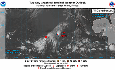
The National Hurricane Center is issuing advisories on Hurricane
Karina, located well west-southwest of the southern tip of the Baja
California Peninsula, on Hurricane Lowell, located several hundred
miles south-southeast of the Hawaiian Islands, and on Tropical
Storm Marie, located several hundred miles south of the southern
tip of the Baja California Peninsula.
Offshore of Southwestern Mexico:
An area of low pressure could form well offshore of southwestern
Mexico over the weekend. Gradual development is possible early
next week as the system moves west-northwestward at 10 to 15 mph,
and is likely to remain well offshore of Mexico.
* Formation chance through 48 hours...low...near 0 percent.
* Formation chance through 7 days...low...20 percent.
&&
Public advisories on Tropical Storm Marie are issued under WMO
header WTPZ33 KNHC and under AWIPS header MIATCPEP3.
Forecast/Advisories on Tropical Storm Marie are issued under WMO
header WTPZ23 KNHC and under AWIPS header MIATCMEP3.
$$
Forecaster Pasch