

000
ABPZ20 KNHC 012327
TWOEP
Tropical Weather Outlook
NWS National Hurricane Center Miami FL
500 PM PDT Tue Sep 1 2026
For the eastern and central North Pacific east of 180 longitude:
Active Systems:
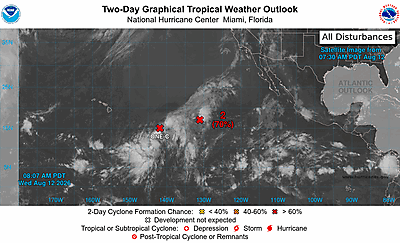
The National Hurricane Center is issuing advisories on Hurricane
Karina, located well west-southwest of the southern tip of the Baja
California Peninsula, on Hurricane Lowell, located several hundred
miles southeast of the Hawaiian Islands, and on Tropical Storm
Marie, located several hundred miles southwest of southwestern
Mexico.
Offshore of Southwestern Mexico:
An area of low pressure could form well offshore of Mexico over the
weekend. Gradual development is possible early next week as the
system moves west-northwestward at 10 to 15 mph, and is likely
to remain well offshore of Mexico.
* Formation chance through 48 hours...low...near 0 percent.
* Formation chance through 7 days...low...20 percent.
&&
Public advisories on Tropical Storm Marie are issued under WMO
header WTPZ33 KNHC and under AWIPS header MIATCPEP3.
Forecast/Advisories on Tropical Storm Marie are issued under WMO
header WTPZ23 KNHC and under AWIPS header MIATCMEP3.
$$
Forecaster Katz/Kelly