

315
ABPZ20 KNHC 010532
TWOEP
Tropical Weather Outlook
NWS National Hurricane Center Miami FL
1100 PM PDT Mon Aug 31 2026
For the eastern and central North Pacific east of 180 longitude:
Active Systems:
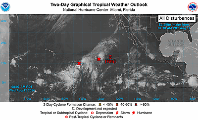
The National Hurricane Center is issuing advisories on Hurricane
Karina, located well west-southwest of the southern tip of the Baja
California Peninsula, and on Tropical Storm Lowell, located well
southeast of the Hawaiian Islands.
Well Offshore of Southwestern Mexico (EP95):
Satellite-derived wind data indicate that a tropical storm appears
to be forming with an area of low pressure located about 500 miles
south-southwest of Manzanillo, Mexico. Advisories on this system
will likely be initiated on early Tuesday. The system is moving
northwestward around 10 mph. For more information, including storm
warnings, please see the High Seas forecast issued by the National
Weather Service.
* Formation chance through 48 hours...high...near 100 percent.
* Formation chance through 7 days...high...near 100 percent.
&&
High Seas Forecasts issued by the National Weather Service
can be found under AWIPS header NFDHSFEPI, WMO header FZPN02
KWBC, and on the web at ocean.weather.gov/shtml/NFDHSFEPI.php
$$
Forecaster Pasch