

000
ABPZ20 KNHC 121142
TWOEP
Tropical Weather Outlook
NWS National Hurricane Center Miami FL
500 AM PDT Wed Aug 12 2026
For the eastern and central North Pacific east of 180 longitude:
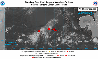
Central Pacific (CP93):
A low pressure area is located about 1050 miles east-southeast of
the Hawaiian Islands. The associated shower and thunderstorm
activity is currently disorganized. However, environmental
conditions are conducive for further development, and a tropical
depression or storm is expected to form within the next day or
so while the system moves generally west-northwestward at 10 to 15
mph. Interests in the Hawaiian Islands should closely monitor the
progress of this system.
* Formation chance through 48 hours...high...90 percent.
* Formation chance through 7 days...high...90 percent.
Western East Pacific (EP99):
A low pressure system located about midway between Hawaii and the
west coast of Mexico is producing disorganized shower and
thunderstorm activity. While this disturbance has changed little
in organization during the past few hours, any significant increase
in the organization of the associated showers and thunderstorms
would result in the formation of a tropical depression today. The
system is forecast to move slowly westward or northwestward over the
next couple of days and encounter less favorable environmental
conditions late this week.
* Formation chance through 48 hours...high...70 percent.
* Formation chance through 7 days...high...70 percent.
$$
Forecaster Pasch/Pierce