

000
ABPZ20 KNHC 121742
TWOEP
Tropical Weather Outlook
NWS National Hurricane Center Miami FL
1100 AM PDT Wed Aug 12 2026
For the eastern and central North Pacific east of 180 longitude:
Active Systems:
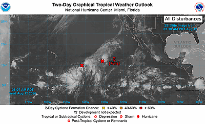
The National Hurricane Center is issuing advisories on
Potential Tropical Cyclone One-C, located about 900 miles
east-southeast of Hilo, Hawaii.
* Formation chance through 48 hours...high...90 percent.
* Formation chance through 7 days...high...90 percent.
Western East Pacific (EP99):
A low pressure system located about midway between Hawaii and the
west coast of Mexico is producing disorganized shower and
thunderstorm activity. These showers and thunderstorms have not
become better organized since last night. However, a significant
increase in organization could still result in the formation of a
tropical depression later today or tonight before the system
moves into less conducive environmental conditions thereafter.
* Formation chance through 48 hours...medium...60 percent.
* Formation chance through 7 days...medium...60 percent.
&&
Public Advisories on Potential Tropical Cyclone One-C are issued
under WMO header WTPA32 PHFO and under AWIPS header HFOTCPCP2.
Forecast/Advisories on Potential Tropical Cyclone One-C are issued
under WMO header WTPA22 PHFO and under AWIPS header HFOTCMCP2.
$$
Forecaster Pasch/Pierce