

000
ABNT20 KNHC 121356
TWOAT
Special Tropical Weather Outlook
NWS National Hurricane Center Miami FL
1000 AM EDT Wed Aug 12 2026
For the North Atlantic...Caribbean Sea and the Gulf of America:
Updated for the Central Atlantic Sub-Tropical System.
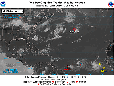
Central Tropical Atlantic (AL92):
An area of showers and thunderstorms associated with a tropical wave
is located about 900 miles west-southwest of the Cabo Verde
Islands. Environmental conditions are forecast to be conducive for
development during the next couple of days, and a tropical
depression will likely form while the system moves westward to
west-northwestward across the central tropical Atlantic.
* Formation chance through 48 hours...high...80 percent.
* Formation chance through 7 days...high...80 percent.
Central Subtropical Atlantic (AL93):
Recent satellite wind data indicate that the circulation
associated with the low pressure area located about 1050 miles
east-northeast of Bermuda has become better defined and the
system is producing tropical-storm-force winds to the southeast of
the center. The system is likely to become a short-lived tropical
storm while it moves eastward to east-northeastward at around 20 mph
across the central subtropical Atlantic. Addition information on
this system is found in High Seas Forecasts issued by the National
Weather Service.
* Formation chance through 48 hours...high...80 percent.
* Formation chance through 7 days...high...80 percent.
Eastern Tropical Atlantic:
A tropical wave just offshore of the coast of west Africa is
producing disorganized showers and thunderstorms. Environmental
conditions are forecast to be generally conducive for some
development of this system during the next several days while it
moves westward or west-northwestward across the eastern and central
tropical Atlantic.
* Formation chance through 48 hours...low...20 percent.
* Formation chance through 7 days...low...30 percent.
&&
High Seas Forecasts issued by the National Weather Service
can be found under AWIPS header NFDHSFAT1, WMO header FZNT01
KWBC, and online at ocean.weather.gov/shtml/NFDHSFAT1.php
$$
Forecaster Brown/Katz